Tar Creek Superfund Site

Tar Creek Superfund Site

Site Documents (click here)

Tar Creek Facts:

The Tar Creek Superfund Site is part of the Tri-State Mining District, which includes northeastern Oklahoma, southeastern Kansas, and southwestern Missouri.  The site originally mined lead and zinc to make bullets during both World Wars.  Mining waste, known locally as “chat”, was left on the surface of the site when mining operations ceased in the 1970s.  Chat contains concentrations of lead, zinc, and cadmium that are a risk to human health and the environment.  People should avoid contact with chat.  Cleanup of the over 30 million tons of chat is continuing at the Tar Creek Superfund Site.

Contact Information:

DEQ Program Manager: Brian Stanila (405) 702-5138

Free Yard Testing: Ellen Isbell (405) 702-5129

DEQ Press Contact: Erin Hatfield, (405) 702-7119

Ottawa County Residents should be aware of:

  • Chat Use Restrictions: Do not use chat for residential uses, such as in your driveway, yard, or garden.
  • Chat Safety: Do not allow children to play in areas with chat.
  • Free Yard Testing: If you live in Ottawa County and suspect that your yard has chat contamination, please contact DEQ’s Hotline at 1-800-522-0206 to get your yard tested.

Tar Creek OU2 Interactive Map (click here)


Click to View Tar Creek OU4 Status Map

Tar Creek Information:

Site Information (click to expand)

Location: Ottawa County, Oklahoma

Township and Range: Section 16-21 and 29-32, Township 29N, Range 24E; Section 5-6, Township 28N, Range 24E; Section 5-8, 18-19, and 30, Township 28N, Range 23E; Section 13-36, Township 29N, Range 23E; Section 1, 12-13, 24-25, and 30, Township 28N, Range 22E; and Section 24-25 and 36, Township 29N, Range 22E

Latitude/Longitude: 36.98591483, -94.82934508

Site Type: Mining Activity

Area: 40 square miles/25,600 acres

National Priorities List: Final Listing Date – September 8, 1983

Current Status: Cleanup underway

Cleanup Oversight Agencies: EPA, DEQ, and the Quapaw Nation

Lead Agency: EPA, DEQ, and the Quapaw Nation

Click to View Interactive Site Map

Site History/Background (click to expand)

Site History and Background:

The Tar Creek Superfund Site is part of the Tri-State Mining District, which includes northeastern Oklahoma, southeastern Kansas, and southwestern Missouri. The Tar Creek area encompasses the Oklahoma portion of the Tri-State Mining District, where lead and zinc were mined and milled from about 1900 to the 1960’s. When mining ceased, huge volumes of mining waste, including chat and mill tailings, were left on the surface. Mining and milling produced more than 500 million tons of waste in the Tri-State area. These wastes contain elevated concentrations of lead, cadmium, and zinc and contributed to elevated blood lead concentrations in some communities. Approximately 300 miles of underground mine tunnels underlie the Oklahoma portion of the District. More than 1,320 mine shafts and thousands of exploratory boreholes and air vents were abandoned. Since mining ceased, subsidence has occurred in several areas due both to roof collapse and erosion of mine shafts. As the mines filled, acidic mine water was generated that severely impacted the Boone aquifer. In 1979 acid mine water began flowing into surface waters, severely impacting surface water quality. Contaminants sometimes leach from waste sources and migrate to surface waters that may have recreational uses.

Site Concerns:

Waste in the form of large chat and tailing piles, contaminated soils, surface and groundwater, are a source of exposure to the citizens of the Tri-State area. Children are the most sensitive population for lead and heavy metal exposures. Prior to yard cleanups, 43% of young children living within the five-city mining area had elevated blood lead concentrations, above the standard set by the Center for Disease Control (CDC). Residential properties being cleaned up and education efforts have resulted in blood lead levels in the children being significantly reduced. DEQ continues to work with the Oklahoma Department of Health and the Ottawa County Health Department on this issue.

Cleanup Information (click to expand)

Cleanup History:

Tar Creek was added to the National Priorities (Superfund) list in 1983. Various attempts to deal with the surface water contamination were made in the 80s and 90s. In 2000, Governor Frank Keating commissioned a study to develop a comprehensive remediation plan for the area. In 2002, DEQ studied metals concentrations in fish from waters impacted by the Tri-State Mining District, including Tar Creek. Fish consumption advisories were issued as a result.

In 2005, the State of Oklahoma, under the Oklahoma Plan, began cleaning up some contaminated areas and restored 329 acres of land to beneficial use. In 2006, the State of Oklahoma passed legislation that allowed for the voluntary buyout of citizens with children in the area. In 2010, EPA began the implementation of the Operable Unit (OU) 4 Record of Decision (ROD) work that involves remediating properties to allow for beneficial reuse and voluntary buyout of citizens of the Relocation Assistance Zone.

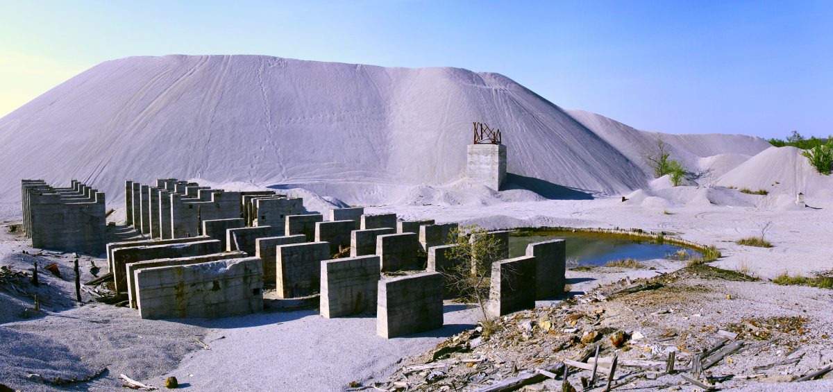
Chat has been sold as road building material and has been widely used as fill material but approximately 30 million tons of chat remain in the Tar Creek area. The University of Oklahoma’s Center for Restoration of Ecosystems and Watersheds (CREW) has partnered with DEQ on two projects to bioremediate groundwater discharging from abandoned mines. This treatment process uses a series of wetland ponds to naturally remove lead, zinc, cadmium, and iron from the water, and then discharges it into a tributary of Tar Creek. DEQ, EPA, and the Quapaw Nation continuously work with local communities, public, and private organizations within the Tri-State area, to monitor the effects of remaining mine wastes and implement projects that promote better land, water, and air quality.

Status:

  • Operable Unit 1 Groundwater: This OU is in the Operations and Maintenance (O&M) phase.  As part of O&M activities, DEQ conducts annual groundwater monitoring and inspection of diversion dike structure.  DEQ also continues to plug abandoned wells in order to protect the local drinking water aquifer.
  • Operable Unit 2 Residential Properties and High Access Areas:  This OU is in Remedial Action phase.  Since 1997, EPA,the City of Commerce, and DEQ have tested and remediated yards, alley ways, and public areas throughout Ottawa County.  Approximately 3,000 residential properties and high access areas have been remediated since the initiation of remedial efforts.  In addition, blood lead screening and community health education continues under the direction of the Ottawa County Health Department.  Any residential properties in Ottawa County that have not previously been sampled and/or cleaned up can contact DEQ for free yard testing (See Above).
  • Operable Unit 3 Drum removal in Cardin: This operable unit has been completed.
  • Operable Unit 4 Chat Piles, Other Mine and Mill Wastes, Smelter Wastes:  Cleanup is ongoing and to date has been concentrated in the distal areas of the Site.  This has resulted in the remediation of approximately 4,800 acres with over 7.1 million tons of source material being removed and disposed at the Central Mil Repository.  In addition, 1.25 million tons of source material has been marketed.  Remediation will continue with a focus on the Elm Creek and Beaver Creek watersheds.

Voluntary Buyout of citizens within the Relocation Assistance Zone has been completed.  Between 2006 and 2010, approximately 530 properties were bought out by the Lead-Impacted Communities Relocation Assistance Trust (LICRAT).  Bought-out properties included homes, lots, and buildings owned by both residents and business owners.  Ownership of these properties was transferred to LICRAT for demolition and ultimately to the Quapaw Nation for re-use.

  • Operable Unit 5 Surface Water and Sediment:  EPA Regions 6 and 7 are coordinating with three states (Oklahoma, Missouri, and Kansas), nine Tribes (Quapaw Nation, Peoria Tribe, Ottawa Tribe, Miami Tribe, Eastern Shawnee Tribe, Modoc Tribe, Wyandotte Nation, Seneca-Cayuga Nation, and Cherokee Nation), and the local communities to characterize sediment and surface water throughout the Spring River and Neosho River watersheds.  EPA recently released the Final Revised Human Health Risk Assessment and is currently working on the Remedial Investigation (RI) and Feasibility Study.

Activities across the watersheds include data gap sampling to support the RI and additional risk assessment; data gap sampling to support sediment modeling; pilot study implementation to provide data to support evaluation of potential cleanup technologies; and watershed sampling at gaging stations across the area to support modeling efforts.


Did You Know?

The lead and zinc produced at Tar Creek was used to make bullets during both World Wars.

Land Use Restrictions and Regulatory Profile (click to expand)

Land Use Restrictions:

Deed notices have been filed on all Lead-Impacted Communities Relocation Act Trust (LICRAT) purchased properties, the OU2 Repository, and multiple OU4 cleanup sites.  To obtain copies of deed notices visit the DEQ IC Viewer

Regulatory Profile:

  • Sources of Contamination: Lead and zinc ore, mining, milling, and smelting activities
  • Contaminants of Concern: Lead, cadmium, and zinc
  • Surface Water Impacted: Tar Creek, Neosho River Watershed, and Spring River Watershed
  • Groundwater Impacted:  Boone and Roubidoux Aquifers (Near Picher and Quapaw)