Compass Industries Landfill Superfund Site
About this Superfund Site
Location: Sand Springs, Tulsa County, Oklahoma
Township and Range: Section 18, Township 19 North, Range 12 East
Latitude/Longitude: 36.12462600, -96.07871000
Alternate Names: Avery Drive Site, Chandler Park Landfill, Chandler Dump,Tulsa Refuse Dump #1, and Berryhill Site
Site Type: Abandoned Landfill
Area: 0.07 square miles/42 acres
National Priorities List: Final Deletion Date – July 18, 2002
Current Status: Cleanup complete
Click to View Interactive Map
Cleanup Oversight Agencies: DEQ and EPA
Lead Agency: DEQ
Office: DEQ, Land Protection Division, (405) 702-5100
DEQ Site Project Manager: Chanh Le, (405) 702-5102
DEQ Press Contact: Erin Hatfield, (405) 702-7119
Site History and Background:
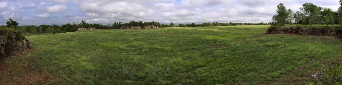
The Compass Industries Site is an abandoned landfill located in a former limestone quarry west of the Tulsa metropolitan area. The site is 0.25 miles south and 200 feet above the Arkansas River. The nearest residence is 0.25 miles from the site. The site operated as a municipal landfill between 1972 and 1976 under permit conditions that did not allow the disposal of industrial waste at the site. However, industrial waste was disposed in the landfill counter to regulations and permit conditions. Records show that the site accepted three categories of waste: solids, liquids, and sludges, which included acids, caustics, potentially toxic solvents, and potentially carcinogenic materials.
Cleanup History:
Long-term human health exposure is controlled with the capping of contamination, diversion of surface water, continued operation and maintenance, institutional control enforcement, and review of the remedy every five years. The ground water migration and exposure pathways are controlled by operation and maintenance of the cap. Five-year review recommendations for general operation and maintenance included:
- Annual removal of woody vegetation
- Adding more rip-rap (rock used to armor shorelines) where necessary
- Raking approximately every 4 years, if mowing continues at the site
- Continued periodic checks for animal burrowing
- Periodic inspection of the cap to ensure that the full 24-inches remains intact
Cleanup Status:
Cleanup completed in June 1991; site deleted from the National Priorities List on July 18, 2002.
Did you Know?
During the 1970’s, several fires were reported at the landfill. The most recent fire burned underground for several years before it burnt itself out in 1984.
Land Use Restrictions:
Institutional controls in the form of a deed notice have been filed for the site. The notice placed restrictions on use of the land and minimized potential exposures to contaminants. Security fencing and warning signs have been placed around the landfill cap. These controls will protect the remedy and make sure any property redevelopment is appropriate.
Regulatory Profile:
Sources of Contamination: Municipal landfill waste, disposal of industrial waste (against regulations and permit conditions)
Contaminants of Concern: Waste jet fuel, oily sludges, miscellaneous solvents, acids, caustics, bleaches, benzene, polychlorinated biphenyls, and carcinogenic materials
Media Affected: Surface water, ground water, and soil contaminated with organic and inorganic primary pollutants
Surface Water Impacted: Arkansas River
Ground Water Impacted: Hogshooter Formation (shallow aquifer) and Coffeyville Formation; no use of water from either aquifer
Read Supporting Documents