Imperial Refining Co. Superfund Site
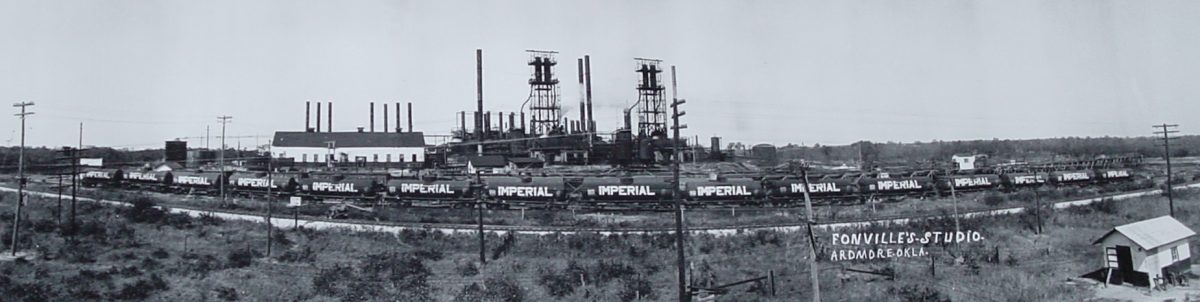
Photo courtesy of Greater Southwest Historical Museum
About this Superfund Site
Location: Ardmore, Carter County, Oklahoma
Township and Range: SE 1/4 Section 20, Township 4S, Range 2E and SW 1/4, NW 1/4, Section 21, Township 4S, Range 2E
Latitude/Longitude: 34.19491367, -97.10792917
Site Type: Abandoned Refinery
Area: 0.113 square miles/72 acres
National Priorities List: Final Listing Date – July 27, 2000, Deleted September 19, 2013
Current Status: Cleanup complete
Click to View Interactive Site Map
Cleanup Oversight Agencies: DEQ and EPA
Lead Agency: EPA
Office: DEQ, Land Protection Division, (405) 702-5100
DEQ Site Project Manager: Steven Gunnels, (405) 702-5173
DEQ Press Contact: Erin Hatfield, (405) 702-7119
Site History and Background:
The Imperial Refining Company (IRC) began crude-oil refining operations at the Site in 1917. The eastern portion of the property was purchased in April 1917 and the western portion was purchased three months later. IRC remained active for 17 years until it went bankrupt in 1934. Due to the absence of environmental regulations during the operational period of IRC, no permits, violations, inspections, or facility operation documentation have been identified, and no records have been found that describe the types of activities that took place on the site. Currently, the land is privately owned, and no commercial activities are occurring.
Did You Know?
One of the Burlington Northern Santa Fe main lines runs across the east side of the site. This line runs from Fort Worth, Texas to Oklahoma City and dates back to 1887.
Cleanup History:
Environmental Protection Agency conducted Removal Assessments in 1998 and 1999 to determine the absence/presence of hazardous materials, the types and concentrations of these substances, waste pile volumes, and to evaluate disposal options. To limit exposure, a perimeter fence was installed in 2004. From early 2005 through early 2007, DEQ investigated the site and evaluated cleanup options. The investigation identified the types, quantities, and locations of contaminants at the IRC Site, while the evaluation developed options to address the contamination. Site cleanup began in February 2008. The cleanup included excavation and off-site disposal of the UST, waste material, contaminated soil, and contaminated pond and Sand Creek sediments. As excavation progressed, waste was found along the borders of the property, throughout the ponds, and surrounding a high pressure gas line. Excavation and removal of waste along the borders was not feasible, safe, or practical due to its proximity to sloped areas supporting the highway, the rail line, and business property, as well as under significant volumes of uncontaminated overburden. A ROD amendment was signed in February 2009, requiring the placement of a clay barrier over waste material left in place.
Cleanup Status:
Operation and Maintenance (O&M) Period – DEQ took over O&M of the site in December 2012. O&M activities include annual site inspections for erosion, property uses, and enforcement of the Institutional Controls (ICs). This activity may also include maintenance of the slopes through grading, seeding, or importing of back fill that may be needed.
Land Use Restrictions:
The site is restricted by deed notices to commercial/industrial reuse because waste remains in place. Institutional Controls (ICs) are required to inform the public of the restrictions and status of the site. ICs protect the remedy and direct appropriate reuse of the site.
Regulatory Profile:
- Sources of Contamination: 15 vertical tank berms, 18 drainage ditches, 12 waste piles, 2 ponds, a central ridge, and an underground storage tank (UST)
- Contaminants of Concern: Tar mats, oil and grease, BTEX (benzene, toluene, ethylbenzene, xylenes), benzo(a)pyrene, and arsenic
- Media Affected: Surface water, surface soil and sediment (0-1 ft below ground surface). Soil concentrations ranged from 1 mg/kg to 90 mg/kg for arsenic and 0.04 mg/kg to 10.2 mg/kg for benzo(a)pyrene
- Surface Water Impacted:Sand Creek
- Ground Water Impacted: No ground water contamination; the site is not located above a major aquifer or its recharge zone; it is also in an unfavorable area for developing a ground water supply.